Archive for Mark BjellandPage 2
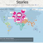
A Connected World as Seen Through the Eyes of Facebook
The link below connects to an interactive map that allows the user to visualize which countries are most socially connected to other countries through Facebook friends. Try to predict which countries are most socially connected and then click on a country and find out if you are right. The importance of language, historical connections, migration […]
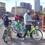
A Nice Ride for Geography Students
The students from Dr. Bjelland’s GEG-336: Urban and Regional Analysis class used the Nice Ride bike rental system to explore park design, historic preservation, and gentrification along the Mississippi riverfront in Minneapolis. Students bicycled through the city’s Mill District, North Loop, and Nicollet Island neighborhoods. The students enjoyed a brisk, sunny fall day as they […]
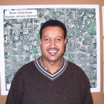
Professor Bati Makes Presentation to U.S. State Department
Lencho Bati, visiting instructor of geography, delivered a presentation to the U. S. State Department in Washington, D.C. on September 24, 2012. Mr. Bati gave his talk to the staff of the African Bureau of the State Department. He urged the United States to take an active role in stabilizing Ethiopia and promoting democracy in […]

Open Farms in the News
The work of Ben Penner, a frequent guest lecturer in geography and environmental studies courses at Gustavus, was featured in a recent StarTribune article. Ben directs the Open Arms farm at the Prairie Institute in Belle Plaine, MN. The farm produces organic produce for free distribution to persons living with life-threatening illnesses.Volunteers work on the […]
The Google vs. Apple Map Wars
Google’s treasure house of geographic data, maps, and images is incredibly valuable and has driven a great deal of internet traffic to their site since they launched Google Maps in 2005. Google employs 7,000 employees to accumulate and update their map data including the streetview photo crews who drive or bicycle down streets around the […]
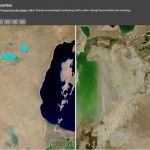
Visualizing the Human Imprint
One of the most valuable tools in GIS is the ability to overlay two images of the same location and then compare before and after images. ESRI has a website that allows the user to go back and forth between Landsat Satellite images using a simple slider bar. You can see the dramatic transformation of […]
Food Deserts
Food deserts are areas where affordable, healthy food is scarce. Supermarkets are non-existent in many small towns and low-income inner-city neighborhoods. That leaves residents with few options other than paying high prices in convenience stores. The problem is particularly acute when residents lack access to a car. Urban geographer Adam Pine of UMD has highlighted […]
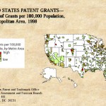
How Geography Fuels Innovation
Some commentators say the world is flat, but a map of innovation suggests otherwise. Patent registrations come from a select group of highly innovative places. Leading the pack in the United States is the San Jose-Sunnyvale-Santa Clara, California metropolitan area–Silicon Valley. In Silicon Valley, a culture of innovation, infrastructure such as research universities and venture […]

The Geography of Political Donations
MinnPost, a fabulous non-profit online journalism project aimed at raising the level of public discourse in Minnesota, has done some excellent work in visualizing spatial data. In preparation for election season, they’ve created an interactive map of political donations to presidential campaigns. If you zoom in and hover with your mouse you can get valuable […]
Google Street View Goes to Nunavut
Google is using a tricycle-based camera and gps system to capture images of the remote Inuit village of Cambridge Bay in Nunavut. The town is only accessible by airplane or by barge during the couple weeks of summer when the bay is ice-free. The program is part of Google Earth’s outreach program. One of the […]